Chiara Solimini
She
received the M.S. Degree in Environmental Engineering from the Tor Vergata
University, Rome, in December 2002, with the dissertation “High resolution
multi-spectral analysis of urban areas with QuickBird imagery and sinergy
with ERS data”. In November 2003 she starts the Geoinformation PhD programme
at the same University. Her research is focused on classification and change
detection over urban areas using neural network algorithms and multi-temporal
high resolution QuickBird images. The idea is to develop a neural network
apt to classify a variety of multi-spectral images of cities arbitrarily located
in the world. The methodology includes: to use different wave-number spectra
to understand the origin of significant features in the images that arise
from different urban environments, to classify the images with the neural
network algorithm with respect to the most relevant features, to study the
optimization of the neural net topology that is most appropriate to classify
the urban environment, to produce classification maps to analyze the urbanization
processes. Recently, she started to address the problem of mass storage, related
to the use of very high spatial resolution data, with compression techniques
exploiting transform algorithms. From January 2005 she has started a collaboration
with the Aerospace Department of the University of Colorado at Boulder (Boulder,
CO, U.S.A.) and with the DigitalGlobe Co. (Longmont, CO, U.S.A.), that provide
the QuickBird images, focused on high resolution urban monitoring and change
detection analysis.
Publications:
F. Pacifici, F. Del Frate, C. Solimini, W. J. Emery "Neural
Networks for Land Cover Applications", in Computational Intelligence
for Remote Sensing, Manuel Grana, Richard Duro, Eds. Studies in Computational
Intelligence, Springer, in press.
F. Del Frate, F. Pacifici, G. Schiavon, C. Solimini, "Use
of Neural Networks for automatic features extraction from high resolution
imagery", IEEE Trans. Geosci. Remote Sens., vol. 45, pp. 800 - 809.F.
Del Frate, F. Pacifici, C. Solimini, W. J. Emery, "A new method for assessing
urban change detection in high-resolution optical satellite imagery",
IEEE Trans. Geosci. Remote Sens., vol. 45, pp. 2940 - 2952.
G. Schiavon, F. Del Frate, C. Solimini, "High resolution
multi-spectral analysis of urban areas with QuickBird imagery and sinergy
with ERS data", Proc. IGARSS, vol. 3, Toulouse, France, July 21-25, pp.
1972-1974, 2003.
F. Del Frate, G. Schiavon, C. Solimini, "Satellite
urban land use monitoring with multi-spectral high resolution imagery and
multi-temporal SAR data", Tyrrhenian International Workshop on Remote
Sensing, Isola d'Elba, Italy, September 2003.
F. Del Frate, G. Schiavon, C. Solimini, "Application
of Neural Networks algorithms to QuickBird imagery for classification and
change detection of urban areas", Proc. IGARSS'04, vol. 2 , Anchorage,
Alaska, USA, September 20-24, pp. 1091-1094, 2004.
B. Buttarazzi, F. Del Frate, C. Solimini, "A user-friendly
automatic tool form image classification based on neural networks", 5
th International Symposium, Remote Sensing of Urban Areas (URS 2005), Tempe,
AZ, USA, March 2005.
F. Del Frate, G. Schiavon, C. Solimini, "Change detection
in urban areas with QuickBird imagery and Neural Networks algorithms",
5 th International Symposium, Remote Sensing of Urban Areas (URS 2005), Tempe,
AZ, USA, March 2005.
F. Del Frate, G. Schiavon, C. Solimini, "Use of high
resolution satellite data for change detection in urban areas", ESA-EUSC
2005: Image Information Mining – Theory and Application to Earth Observation,
ESRIN, Frascati, October 2005.
F. Del Frate, G. Schiavon, C. Solimini, "Individuazione
di cambiamenti in aree urbane tramite dati Quickbird e algoritmi neurali",
Workshop congiunto AIT e SIFET sul Rilevamento Urbano da Piattaforma Aerea
e Satellitare, Mantova, Italia, Dicembre 2005.
F. Del Frate, F. Pacifici, C. Solimini, W. J. Emery, "Urban
Change Detection by Using Neural Networks Algorithms and High Resolution Optical
Satellite Imagery", Proc IGARSS'06, Denver, Colorado, U.S.A., August
2006.F. Del Frate, F. Pacifici, C. Solimini, W. J. Emery, "A new neural
network architecture for automatic Urban Change Detection >From Satellite
Imagery", ESA-EUSC 2006: Image Information Mining for Security and Intelligence,
EUSC, Torrejon Air Base, Madrid, Spain, November 2006.
F. Del Frate, F. Pacifici, C. Solimini, W. J. Emery, "A
New Neural Architecture for Detecting Urban Changes in Quickbird Imagery",
Urban Remote Sensing Joint Event, Paris, France, April 2007, pp. 1 -7.
F. Pacifici, F. Del Frate, C. Solimini, W. J. Emery, "A
robust neural network design for detecting changes from multispectral satellite
imagery", Proc. IGARSS'07, Barcelona, Spain, 23-27 July 2007.
C. Solimini, W.J. Emery, D. Solimini, "Wavenumber spectra
for VHR urban characterization", IGARSS'08, Boston, MA, U.S.A., Jul.
2008.
A. Burini, C. Solimini et al. "Solar radiance estimation
by means of METEOSAT 2nd generation and neural processing: A vineyard precision
farming case", IGARSS'08, Boston, MA, U.S.A., Jul. 2008.
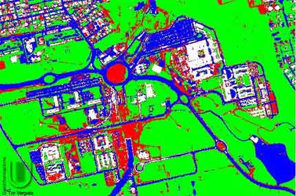
Neural Network classification map of the Tor Vergata University campus:
white: buildings, red: bare soil, green: vegetated area, blue: roads.
| geoinformation |