 |
 |
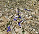 |
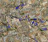
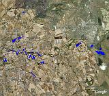
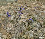
Heavy rain occurred in the second week of December 2008 in the Rome area.
The river Aniene, a tributary of Tiber, flooded several flat areas around its riverbed.
RADARSAT-2 acquired a fully polarimetric image in the morning of 13 December, when water covered the surface. A comparison of the 13 December image with one previously acquired (in October 2008) allowed the flooded areas to be mapped in near-real time through a change detection technique.
The images, utilizing GoogleMap (©2008 Google) show the flooded areas (in blue) around the Aniene river as obtained by the RADARSAT-2 SAR images.
Data and image processing by GEO-K s.r.l., Rome, Italy (Alessandro Burini) and Earth Observation Laboratory, Dipartimento di Informatica, Sistemi e Produzione, Tor Vergata University, Rome, Italy.
The RADARSAT-2 fully polarimetric images (RADARSAT-2 Data and Product © MacDonald, Dettwiler and Associates Ltd., 2008) have been provided by MDA Geospatial Services Inc. within the Science and Operational Application Research (SOAR) for RADARSAT-2 program, Project N. 1488, P.I. Domenico Solimini.