HIGH-RESOLUTION
SIDE SCAN SONAR AND MULTIBEAM DATA PROCESSING AND MERGING
TO STUDY SUBMARINE INSTABILITY PHENOMENA ON VOLCANIC ISLANDS
(PONTINE, CAMPANIAN AND AEOLIAN ARCHIPELAGOS)
A. BOSMAN
Extended
abstract:
The PhD activity started with a bibliographical research related to
submarine instability phenomena involving the flanks of the volcanic
islands and to the processing of side scan sonar and multibeam data
(producing a seafloor DTM).
Geophysical data were collected during several oceanographic cruises
carried out to in order to investigate the submarine sectors of Pontine,
Ischia and Stromboli Islands that are all affected by instability phenomena
of different type an acting at different scalas. The collection of a
large amount of geophysical data during the PhD period allowed to get
a remarkable experience in different acquisition and processing techniques.
Most of the research activity was carried out in the framework of the
research project “Conoscenza delle parti sommerse dei vulcani
Italiani ” funded by Gruppo Nazionale di Vulcanologia (GNV). This
project involves many researchers of national and international research
institutes and universities favoring many interdisciplinary exchanges.
During the PhD analysis and tests on the standard processing techniques
ware performed at different research institutions (i.e. National Research
Council Geomare Sud –Napoli) and Investigation companies (i.e.
Coastal Consulting Exploration - Bari) with the aim to verify processing
procedures. The low accuracy and resolution obtained by means of the
standard processing techniques induced us to develop specific processing
techniques aimed to obtain data at highest resolutionFurthermore,
methodologies for automatic matching were developed in order to obtain
an accurate re-calibration of the side scan sonar data. The re-calibration
was obtained by matching side scan sonar with the morphological features
resolved by multibeam data.
During the third PhD year, the 12/30/2002 large scale landslide and
tsunami phenomena occurred on the subaerial and submerged “Sciara
del Fuoco” slope (Stromboli Island) provided a unique chance to
extensively apply marine remote sensing techniques to define pre-post
slide morphoacoustic characters of the submarine slope, for comprehension
of the instability phenomenon.
The availability of a large amount high resolution multibeam data allowed
the testing of the different processing techniques developed during
the first part of the PhD.
Finally, geophysical data collected in the three study areas (Pontine,
Campanian and Aeolian Archipelagos) ware analyzed to define the main
geomorphological features associated with different typology of instability
processes.
![]()
The main objectives of the PhD Thesis are:
-
Development of processing techniques devoted to the generation and integration of different high resolution Digital Terrain Models for a detailed study of the submerged features,
-
re-positioning of the SSS data,
-
individuation of geomorphological features and morphometrical parameters correlated to instability phenomena.
The first result is the development of a processing method for multibeam data based on the analysis of the raw data (bathymetric soundings) working on each single swath . Data analysis revealed that the major error source is represented by the calibration of the motion sensors (roll, pitch, heave, yaw and time delay) used for multibeam data acquisition.
The standard processing techniques should include an analysis of the calibration parameters.
However the accuracy along the vertical and horizontal planes can be increased at least by on order of magnitude if calibration values are directly corrected on the source data.
The proposed methodology includes:- check and removal of the calibration errors
- manual deletion of spike along each single swath. This operation is useful for the eliminating local noises and for obtaining regular soundings surfaces, which can be subsequently statistically and geometrically filtered.
- the mosaicking of the different swaths (already cleaned and filtered), with the application of new statistic filters mainly based on the slope angle and on the soundings density.
- The tinning (triangular irregular network) of the soundings in order to visualize end interpret an high resolution Digital Terrain Model.

The resulting DTM has a resolution of some centimetres which is comparable with high resolution side scan sonar data.
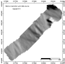 |
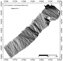 |
| Multibeam bathymetry (Seabat 8111) processed data. Left: standard processing, obtained by grid data source. Right: advanced processing obtained by working on soundings data (Stromboli Island). | |
The second result is the re-calibration of the side scan sonar data based on their matching with the multibeam bathymetry. The re-calibration was performed by draping SSS data on high resolution DTM. This technique highlighted many problems connected to the georeferentiation of side scan sonar data.
Different techniques were used to re-process multibeam and SSS data. Only Ischia and Stromboli dataset were processed because an high resolution bathymetry of the Pontine continental slope was not available.
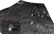
Of the southern flank of the Ischia Island data, were processed to identify and locate large blocks making up the hummocky facies characterizing the debris avalanche deposit.
Both side scan sonar (TOBI system) and multibeam (Seabat 8111) data were processed. Side scan sonar data were automatically filtered to detect the top of the blocks and to determine their coordinates (uncorrected). A different filter was applied on the multibeam DTM in order to identify the top of the blocks and their coordinates (corrected). Couple of homologous points were utilized to match the SSS and multibeam the dataset by means of a automatic procedure.
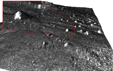
Comparison between the merged data before and after the re-calibration of the SSS TOBI mosaic obtained with no standard automatic procedures. For the TOBI SSS data of Stromboli Island another method of re-calibration was used due to the lack of sharp morphologies for automatic matching. TOBI mosaicking was cut in different parts which were re-calibrated by a manual editing.
Despite of a medium resolution of deep bathymetry data, the geometric correction was obtained by using a DTM where control points can be identified. Processing led to new mosaicking of the sides scan sonar images.At the end of the processing of all the available data a morphological analysis was performed in order to describe the main instability phenomena recognized along the islands flanks an the three study areas. The integrated analysis of SSS multibeam data represents an essential approach for a complete characterization of areas with complex morphologies, such those on the submerged flanks of volcanic islands affected by instability. In particular, long-range SSS data are affected by large errors of positioning so that their interpretation is often ambiguous if only integration with high resolution bathymetric data is made.
The morphological analysis was performed at different scales, depending an the various degree of resolution of the data available for each area (Pontine, Campanian and Aeolian Archipelagoes).The continental slope of the Pontine Islands was investigated by means of different geophysical instrumentation: hydrographic survey from the continental shelf down to 1000 m b.s.l., low resolution multibeam and long range side scan sonar data from 1000 m b.s.l. down to the abyssal plain (3.600 m b.s.l.). The bathymetric data have a lower resolution than at Ischia and Stromboli so that the geomorphological analysis of instability features the for structural analysis were only performed at a regional scale.
The Pontine Island continental slope is characterized by steep sloops (from 10 to 15 degrees) where huge instability phenomena occur. The erosional features extend from the shelf break down to the abyssal plain, so that erosion involves almost all the western part of the slope (about 96%) of the seafloor is affected by same sort of instability. Several failure scarps are located close to the shelf break and at the top of the main ridges that characterize the slope. The instability/erosion processes produce a large amount of debris which is transported by a dense network of channels developing within three wide major valleys. Sediments seem to be transported by grain flows and debris flows.
The morphological analysis of the erosional/instability features led to the re-construction of hierarchization of the mass flows (up to 5th order) and to the location of the source areas.
The merging and draping of the different dataset (single, multibeam and SSS) evidenced the main structural features along the whole continental slope. The analysis of such features, in relationship with the structural data available for the Vavilov abyssal plain suggests that the major structural elements converge towards the northern part of the abyssal plain.The southern part of the Ischia island is characterized by the widest Italian offshore debris avalanche deposit. This deposit is the resulted an exceptional failure event, produced by the collapse of the southern part of the Ischia island. The study area was investigated by means of different geophysical instrumentation (SSS and multibeam data with medium resolution) that allowed to identify the main morphological features. By means of an automatic data processing the number of the outcropping blocks, was estimated an over 5.200; the total and max individual volume of the blocks was defined at 3.5 x 10⁷ m3, and 200’000 m3 to 900’000 m3 respectively.
Moreover, the volume of the mobilized debris during the collapse and the volume of the actual deposit of the debris avalanche on the seafloor were estimated.
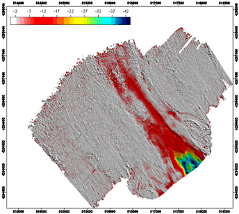
Two DTM were created to calculate debris volumes: about 1.3 x 10⁹ m3 for the present deposit, and about 1.9 x 10⁹ m3 for the mobilized deposit. A maximum thickness of about 60 m of the debris avalanche body was computed.Most of the analyses of the NW flank of the Stromboli island (submerged part of the "Sciara del Fuoco") are related to the area interested by the slide and tsunami event occurred on 12/30/2002. The Stromboli Island is characterized by a complex geological history. The present morphology of the "Sciara del Fuoco" is the result of the different sector collapses occurred in the area. Today this sector is a source area of the debris transported toward the deeper seafloor areas. This site is of particular interest for the fast subaerial and submarine morphological evolution. The submerged slopes ware investigated by means of SSS, multibeam and high resolution seismic surveys. However, due to the presence of complex morphologies and high slope gradients (up to 45°), bathymetric survey on the most effective investigation tool. All the multibeam data collected in this sector have been processed in order to obtain the highest resolution (accuracy of some centimeter in shallow water and of some meters in deep water) and to identify the features connected to the slide event. The comparison of the new data with a pre slide high resolution multibeam survey (performed just 10 months after the event) provided an unique opportunity for identifying slide morphologies and to define the mobilized volume.
Very detailed analyses were performed both an shallow water (from -20 m to -300 m) and deep water (from -300 to -2600m) areas. The shallower surveys show the greatest morphological variations. The most impressive is a huge slide scar, about 600 m wide and over 45 m deep, that can be related to the slide witch was responsible of the tsunami event. From the comparison of pre-post slide DTMs the materials mobilized by the submarine slide is about 9 x10⁶ m3. On the residuals map other two smaller slides outside the main scarp were identified, probably produced by the tsunami wave. Their volume is of 120.000 m3 and 300.000 m3 respectively and their thickness reaches a maxim of 10 m.
Residual map from pre and post-slide multibeam bathymetry. The map highlights major and minor slides and the different debris deposits infilling slide scar.
The residual map also shows the debris infilling the main slide, produced by brecciated lava and erosion of the subaerial flank. The large number of multibeam surveys carried out within a short span of time (few months) allowed the quantitative monitoring of the progressive infilling of the main slide scar.
The submarine slope was also affected by relevant morphological variations resulting from the excavation produced by the sediments transport toward the abyssal plain. Two erosional scars were observed along the submerged flank of the Sciara. They start at the toe of the main scarp (about -400 m) and extended down to a depth of 1.500 m. This erosional features are 150 – 200 m wide and 10 m deep.
By means of the DTM analysis the volume of the removed deposit by excavation of the deeper submarine slope can by estimated in 10 x106 m3. Consequently the overall volume involved in the different instability phenomena occurred on December 30 2002 can by estimated in some 19 x106 m3 only in the submerged sectors (a further 8x10⁶ m3 were computed for the subaerial part).