The artwork Arrivederci Roma by GeoInformation students Chiara Solimini (PhD in 2007) and Fabio Pacifici, based on a satellite image, is being displayed from February 6 - June 28, 2009 in the LeCroy Gallery which is a Gallery of the New York Science Museum.
The artwork was originally selected for the traveling gallery show that opened at the Denver (Colorado, U.S.A.) Museum of Nature & Science in January 2007 and appears in the Art in Science | Science in Art online gallery. Only the top thirty of several hundred entries were selected for the show.
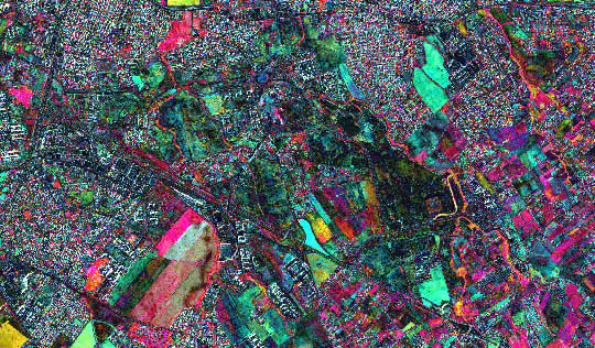
Very-high resolution satellite images have been processed with neural network algorithms to extract change detection maps of urban areas. The image shows the SE subarea of the city of Rome, Italy, acquired by QuickBird satellite. Each pixel of the image is represented by a vector whose components are the logarithm of the ratios of the bands belonging to two multispectral images acquired in 2002 and 2003, respectively. The image forms the input of a neural network suitably trained to find changed pixels. This method allows detecting changes occurring in an urban area, such as new buildings and roads constructed between the two acquisition dates, as well as changes in vegetation.