 The Data Fusion
Contest has been organized by the Data Fusion Technical Committee (DFTC) of
the Geoscience and Remote Sensing Society (GRS-S) of the IEEE. In 2007, the
contest was related to urban mapping using radar and optical data. A set of
satellite radar and optical images (ERS amplitude data and Landsat multi-spectral
data) was made available with the task of obtaining a classified map as accurate
as possible relative to ground reference data depicting land cover and land
use classes for the urban area of interest.
The Data Fusion
Contest has been organized by the Data Fusion Technical Committee (DFTC) of
the Geoscience and Remote Sensing Society (GRS-S) of the IEEE. In 2007, the
contest was related to urban mapping using radar and optical data. A set of
satellite radar and optical images (ERS amplitude data and Landsat multi-spectral
data) was made available with the task of obtaining a classified map as accurate
as possible relative to ground reference data depicting land cover and land
use classes for the urban area of interest.
The winning algorithm was based on a neural network approach. One of the major
advantages of neural networks with respect to statistically based classifiers
is that NNs draw their own input-output discriminant relations directly from
the data and do not require that a particular form of a probability density
function be assumed. The classification procedure was divided into three steps:
preprocessing, neural network classification and post-processing.
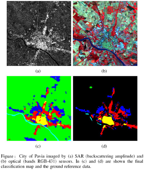
The final classification map, shown in figure, reached the accuracy of 0.9393
in terms of k-coeff. with respect to the unknown ground reference data used
to rank the contest’s results.